Field Exploration & Appraisal
Gas was discovered in the Judith Gas Field in 1989 by the Judith-1 exploration well drilled by Shell Australia. At that time, the discovered gas resource was not considered for further development given market conditions and an abundance of existing gas supply from other fields in the Gippsland Basin.
Emperor Energy has reassessed all available data from the Judith Gas Field including that of a recent 3D seismic survey. This reassessment has resulted in Emperor Energy now considering that a substantial economic gas resource exists at Judith. The Judith-2 appraisal well drilling program will enable a detailed appraisal of this gas resource and if successful will provide Victoria with additional gas reserves as production from existing fields declines.
Proposed Offshore Activities Overview
As part of the overall program, we are planning three separately conducted operational activities in 2026/27.
Planned Operation: Geophysical Survey
This is required to identify seabed topography and any potential hazards at the proposed well location. The survey will be acquired by a special-purpose vessel prior to the geotechnical survey and drilling the Judith-2 well. The vessel will utilise the following survey equipment to collect bathymetry data and detect seabed or shallow geological hazards using:
- Multibeam echo sounder
- Sub-bottom profiler, side scan sonar and magnetometer
- High resolution two-dimensional shallow reflective imaging (2D seismic survey)
While operating within the activity area (4km x 4km box), the single vessel will tow or deploy these sensors overboard. One of the key survey tools is a high resolution shallow 2D seismic survey. This is required to identify any shallow subsurface drilling hazards including geological faults, gas-charged sediments, shallow water flows and buried channels. Equipment will consist of a sound source up to 160 in3 and a 1.5 km streamer towed by a vessel at a speed of ~ 8-9 km/hr (4 – 5 knots).
The Commonwealth Offshore Infrastructure Regulator, provides another good source of information on these types of surveys, also used in offshore wind.
Planned Operation: Geotechnical Survey
This is required to characterise the geological properties of seabed and underlying shallow sediments. Conducted by a single specialized vessel, testing will be collected at up-to 10 locations, within the 1km x 1km area. The vessel will deploy equipment overboard, using the following techniques.
- Core sampling (borehole)
- Piezo cone penetrometer test (PCPT)
- Grab samples
Both the geophysical and geotechnical surveys are commonplace in Australian Waters, such as the Gippsland Basin. They have been conducted recently for, petroleum, carbon capture, offshore wind and energy transmission routes.
The Commonwealth Offshore Infrastructure Regulator, provides another good source of information on these types of surveys, also used in offshore wind.
Planned Operation: Judith-2 Drilling
A jack-up drilling rig will be towed to the Judith-2 location by 2 vessels, the 3 legs lowered to the seabed and the hull jacked out of the water. Drilling commences by drilling the top hole well sections (conductor and surface hole) will be drilled without a riser, which is standard practice. The cuttings (rock chips) and drilling fluids from this section will be discharged to sea.
A riser and blow-out preventer (BOP) will be installed to facilitate the drilling of the deeper well sections once the surface casing is cemented in place. Once the riser and BOP are installed, drilling fluids and cuttings will be returned to the jack-up drilling rig, where the drilling fluids will be separated using solids control equipment. Recovered fluids that have been separated from the cuttings may be directed to centrifuges to remove the finer solids. The cuttings are usually discharged below the water-line and the reconditioned fluids are recirculated into the fluid system. The water-based drilling fluid performs several functions including cooling and lubricating the drill bit; transporting drill cuttings to the surface; and maintaining hydrostatic pressure in excess of formation pressure, thereby preventing the influx of hydrocarbons from the formation into the wellbore. This is the primary well control barrier.
While drilling, Logging While Drilling tools will record and evaluate the physical properties of the geology. In a success case, additional wireline deployed tools will be utilised, including a short Vertical Seismic Profile (VSP) program, which uses seismic (acoustic) sources to map the geological horizons of the gas field. A well test will then complete the appraisal program, with produced hydrocarbons brought to surface and flared-off, to demonstrate the potential flow-rate of future development wells.
The well will be securely plugged and abandoned following drilled, with the well secure all equipment above the seabed will be removed and the rig will depart the activity area.
The drilling rig will be support by (up to) 3 supply vessels, that bring supplies to sustain the drilling operation and the personnel offshore. Helicopters will be used for the transportation of workers, with flights operating daily.
Activities Timelines
The operational activities are scheduled to take place in 2026 or 2027. The timeline is dependent on Emperor Energy receiving the required regulatory approvals and the availability of the specialist vessels and jack-up drilling rig. The below indicative dates will be updated regularly as the project progresses.
- Geophysical Survey. Not commencing before February 2026. Duration ~4 days.
- Geotechnical Survey. Not commencing before April 2026. Duration ~5 days.
- Judith-2 Drilling. Not commencing before May 2026. Duration ~60 days
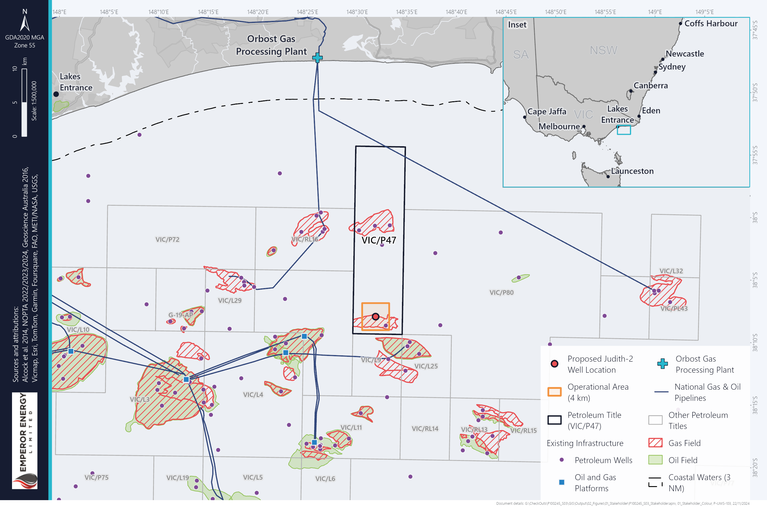
Location
The operational activities will take place in Emperor Energy’s Commonwealth Petroleum Exploration Title, Vic/P47 in the Gippsland Basin.
Vic/P47 covers a total area of 203km2, with the proposed Judith appraisal activities to take place in the southern part of the title. The operational area is 16km2, with the planned Judith-2 well location 37km south of Marlo, 46km southeast from Lakes Entrance on the Gippsland Coast.
Regulatory Approval Process
Emperor Energy’s planned activities will be conducted in accordance with the Offshore Petroleum and Greenhouse Gas Storage (OPGGS) Act 2006 and its corresponding Regulations. The National Offshore Petroleum Safety and Environmental Management Agency (NOPSEMA) being the regulatory agency responsible for assessing our regulatory applications and execution of the operations.
The below sections provide details on the Environment Plan, a key regulatory application under the OPGGS Act.
Environment Plan
Under the Offshore Petroleum and Greenhouse Gas Storage Act (2009), before any petroleum-related activities in Commonwealth waters can commence, an Environment Plan (EP) must be accepted by NOPSEMA.
EP’s include a description of the existing environment and the proposed activities, an evaluation of the impacts and risks, environmental performance outcomes and controls, implementation strategy, and reporting requirements.
The EP is developed further via consultation and feedback with relevant stakeholders, specifically with functions, interests or activities may be affected by the proposed activities.
An EP has been prepared by Emperor Energy for the operations as detailed above, based on previous operations plans and stakeholder feedback. This EP is now being further updated and any feedback received during this period of consultation, may be incorporated into the next submission.
Consultation with Relevant Persons
The purpose of consultation under regulation 25 of the OPGGS Environment Regulations is to ensure that authorities, persons or organisations which are potentially affected by activities are consulted and their input considered in the development of environment plans.
Consultation is designed to ensure that relevant persons are identified and given sufficient information and a reasonable period to allow them to make an informed assessment of the possible consequences the proposed petroleum or greenhouse gas activity may have on them. Regulation 25 is also intended to ensure the titleholder (Emperor Energy) considers and adopts appropriate measures in response to the matters raised by relevant persons. These actions will in turn inform the management of environmental impacts and risks to which the activity and environment plan relate.
NOPSEMA Guideline: Consultation in the course of preparing an environment plan
Environment Description
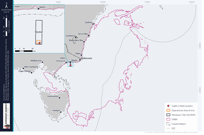
EPs include a detailed description of the EMBA by the activities described in the EP. The EMBA is the largest geographic area where operational activities could potentially have a direct or indirect environmental impact under worst-case scenarios.
The defined EMBA for the Judith-2 Drilling EP will include the following marine fauna which may be present in the area at various times during activities described within the EP:
- Blue, humpback and fin whales, particularly during the summer months
- Southern right and minke whales, particularly during the winter months
- Common dolphins and shark species throughout the year
- New Zealand and Australian fur seals throughout the year
- Migratory birds.
Importantly, Emperor Energy will not be conducting regulatory activities within Commonwealth or state marine parks. However, within the broader planning area for emergencies, National Marine Parks and State Marine Protected areas are included.
Socio-economic and cultural values and sensitivities within the EMBA include:
- Commonwealth managed fisheries, including southern and eastern scalefish and shark fishery
- Victorian, Tasmanian, and New South Wales managed fisheries, including rock lobster and giant crab
- Commercial shipping activities
- Offshore Wind Industries
- Subsea cables
- Sea Country cultural values and sensitivities held by First Nation peoples
- Cultural heritage including shipwrecks
- Recreational fishing
- Recreational diving focussed on shipwrecks and reefs close to the shoreline
- Significant tourism features and activities associated with the Gippsland region, including Marlo, Cape Conran, Ninety Mile Beach, Lakes Entrance and Mallacoota.
Environment that May Be Affected
The environment that may be affected (EMBA) is defined as an area where a change to ambient environmental conditions has the potential to occur as a result of the activity.
The description of the environment considers the largest possible extent of potential change and defines the environment, including its values and sensitivities, within. The description of EMBA for the Judith-2 Exploration Drilling Campaign has been spatially defined by oil spill modelling. The largest predicted spatial extent that hydrocarbon could extend may occur during a Loss of Well Control (LOWC) event, referred to as the EMBA. The EMBA has been defined based on the combined outcomes of stochastic modelling for MDO scenario (i.e. cumulative extent of a total of 100 model simulations per season) and is based on a conservative low threshold for each of the modelled oil components (1 g/m2 floating, 10 ppb dissolved, 10 ppb entrained, 10 g/m2 shoreline) to predict an extent.
This special extent is used to consider stakeholders and relevant persons, that may my affected by the planned operations.
Environmental Management of Potential Impacts
The objective of the Environment Plan is to minimise environmental and social impacts associated with the proposed activities. The operational activities will incur both planned (certain) and potential (risk) impacts upon the environment and stakeholders.
The EP assessment process considers these planned operations, durations, environmental and social impacts and considers how to reduce and manage the impact or risk, to As Low As Reasonably Practicable.
The below linked PDF file provides details on this assessment and the proposed control measures.
Providing your feedback
We are seeking feedback from our proposed operational plans, to minimalize their effect on stakeholders and the environment.
Your rights and Emperor Energy’s obligations are described in the NOPSEMA brochure “Consultation on offshore petroleum environment plans – Information for the community”.
Please also advise if you are aware of any other relevant persons (individuals or organisations) who you think we should consult with. Emperor Energy is required to provide relevant persons sufficient information and time to make an informed assessment of the possible consequences of our activities on their functions, interests and activities.
If you are a relevant person Emperor Energy looks forward to a 2-way dialogue that helps reduce potential impacts and risks to as low as reasonably practical and acceptable levels. Good consultation should be mutually beneficial.
Email us at stakeholder@emperorenergy.com.au
COMING SOON
A new dedicated information site will soon be launched. Check back soon!
More Information
Consultation
Emperor Energy is identifying relevant persons and welcomes comments and feedback and encourages a 2-way dialogue about the potential impacts of the proposed activities. If you require further information or have any comments regarding the proposed exploration well, please contact us at stakeholder@emperorenergy.com.au.
Our consultation with you will be included in the Environment Plan for the proposed activity, which will be submitted to the National Offshore Petroleum Safety and Environmental Management Authority (NOPSEMA) for assessment.